A rapidly intensifying coastal storm is expected to evolve into a powerful bomb cyclone this weekend, bringing heavy snowfall, damaging winds, and coastal flooding to large portions of the southeastern United States, while the Northeast faces an uncertain but potentially disruptive brush with winter weather.
Meteorologists say computer forecast models are increasingly aligned on the development of a low-pressure system off the Carolina coast early Saturday. As the system rapidly strengthens — a process known as bombogenesis — it is expected to draw in frigid Arctic air, creating dangerous winter conditions across a region unaccustomed to prolonged snow and ice.
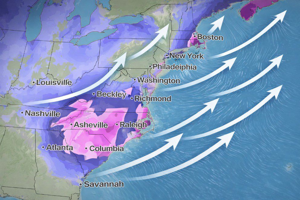
More than 20 million people across the Southeast are currently under winter storm watches, including residents of Charlotte, Raleigh, Norfolk, and Atlanta. Many of these areas are still recovering from last weekend’s deadly winter storm, which caused widespread power outages, hazardous travel, and infrastructure disruptions.
Southeast and Southern Virginia: Heavy Snow and Dangerous Winds
Forecasters expect snow and strong winds to begin late Friday and intensify through Saturday across northern and eastern Georgia, the Carolinas, and southern Virginia. While exact snowfall totals are still being refined, confidence is high that conditions will deteriorate rapidly, especially with cold air already entrenched across the region.
Blizzard conditions are possible along the coast of southeast Virginia and northeast North Carolina by Saturday night, with wind gusts reaching up to 60 miles per hour. In these areas, heavy snow combined with powerful winds could reduce visibility to near zero for several hours, meeting the official criteria for a blizzard.
The highest snowfall totals are expected in central and eastern North Carolina and southern Virginia. Cities such as Greensboro, Raleigh, and Norfolk could see six inches or more, while inland locations — including Columbia and parts of the Atlanta metropolitan area — may experience lighter but still disruptive accumulations.
Strong winds may lead to blowing snow, downed trees, and scattered power outages, particularly if heavier snow bands develop. Snowfall is expected to taper off from west to east by Sunday afternoon, though lingering impacts could persist.
Northeast: Uncertain Track, High Stakes
Confidence in the forecast drops sharply farther north. The eventual path of the storm will determine whether the mid-Atlantic and Northeast experience a minor disturbance or a significant winter event.
At present, the storm is expected to track slightly offshore, delivering only a glancing blow to cities such as Washington, Philadelphia, and New York City, where impacts may be limited to gusty winds and light snow.
However, Boston and parts of southeastern New England face a greater risk of accumulating snow due to their proximity to the storm’s projected path. A shift of just 100 to 200 miles could dramatically alter outcomes along the Interstate 95 corridor.
Coastal Flooding and Broader Risks
Coastal flooding is a growing concern from the Southeast through New England, especially as the storm coincides with high tides ahead of Sunday’s full moon. Emergency officials urge residents in low-lying coastal areas to prepare for flooding and avoid unnecessary travel during peak storm conditions.
Meteorologists emphasize that while uncertainty remains, the potential impacts are significant and preparations should be taken seriously.